
[Typhoon Breaking News] No. 17 Typhoon Tapa Current location and travel path! ... "Jeju Airport-Gimhae Airport and other flight information needs to check!"
2019-09-21 12:13:13
The 17th Typhoon Tapa (TAPAH), which occurred on the far east of the Philippines at about 3 pm on September 19, is heading north, attracting interest in the route.
According to the Korea Meteorological Agency, Saturday, the 21st, is expected to be overcast and heavy rain due to the impact of the typhoon No. 17 typhoon.
According to the Korea Meteorological Agency, Jeju Island will have rain of 150 ~ 400㎜ by 22nd night.
Be careful not to cause any damage as it may rain 600mm or more in the mountains of Jeju.
In Gangwon, Yeongdong, Gyeongsang-do, and Jeonnam, rain will fall by 100-350mm until the morning of 23rd.
It will rain 10-40 mm in Seoul, northern Gyeonggi, northern Gangwon, and northern Chungnam.
An official from the Korea Meteorological Administration said, "More rain will fall around Jeju Island, the South Coast, the East Coast, and the Jirisan Mountain until the day after tomorrow (May 23)," he said. "Be careful not to injure floods or flood the rivers."
Beware of strong winds.
The maximum instantaneous wind speed can be 35 ~ 45m / sec in Jeju Island, South Coast, East Coast, and island area, and it can be 15 ~ 30m / sec in other regions.
By 23 days, the weather may be disrupted by strong winds.
If you plan to take a flight, you need to check the flight information in advance.
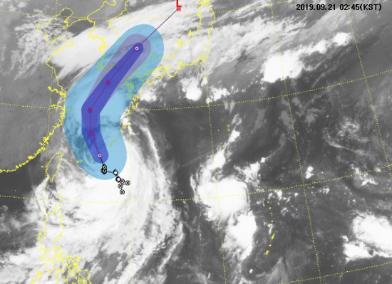
No. 17 Typhoon Tapa (TAPAH) is a medium-sized force with a central air pressure of 975 hectopascals (hPa) at around 3 am on the 21st, a maximum wind speed of 115 km / h, and a 340 km of strong wind blasts, about 9 km per hour from sea around 240 km southwest of Okinawa, Japan.
It is going north.
No. 17 Typhoon Tapa is expected to approach north and southwest by approaching the sea around 280 km northwest of Okinawa, raising the power to a medium-sized river with a central pressure of 965 hPascal (hPa) around 3 pm on Saturday.
The 17th typhoon tapa is expected to go north-south northward towards Busan by approaching the sea about 400km north of Seogwipo while maintaining a heavy class force around 3 am on Sunday.
Typhoon Tapa is northeast passing the sea near Busan on the afternoon of 22nd, and it is expected to change from the sea to about 430km northwest of Sendai in Japan around 3pm by 3am on the 23rd.
No. 17 Typhoon Tapa (TAPAH), a name submitted by Malaysia, refers to freshwater fish from the catfish family and is expected to change to temperate cyclone within 60 hours.
o Strong wind warning: Jeju Island, Jeollanam-do (Geomundo.
Donghae Nambu offshore (Ulsan offshore)
(1) Heavy Rain Preliminary Report o September 21 AM: Jeju Island o September 21 Day: Ulsan, Busan, Gyeongsangnam-do (Jinju, Yangsan, Namhae, Goseong, Geoje, Sacheon, Tongyeong, Sancheong, Hadong, Gimhae, Changwon),
Jeollanam-do (Jangheung, Wando, Haenam, Gangjin, Suncheon, Gwangyang, Yeosu, Boseong, Goheung) o Sep 21 afternoon: Daegu, Gyeongsangnam-do (Hapcheon, Geochang, Hamyang, Changnyeong, Haman, Ryeong, Miryang), Gyeongsangbuk-do (Gyeongbuk North-East)
Mountain, Uljin Flat, Qingdao, Gyeongju, Pohang, Yeongdeok, Gimcheon, Chilgok, Seongju, Goryeong, Army, Gyeongsan, Yeongcheon, Gumi)
(2) Strong wind preliminary special report o September 21 Daytime: Ulsan, Busan, Gyeongsangnam-do (Namhae, Goseong, Geoje, Tongyeong), Jeollanam-do (Jangheung, Wando, Haenam, Gangjin, Suncheon, Gwangyang, Yeosu, Boseong, Goheung) o 09
May 21 Afternoon: Heuksan Island and Hongdo o September 22 Morning: West Sea 5 degrees o September 22 AM: Incheon (Ongjin)
(3) Typhoon Preliminary News-September 21 Afternoon: South Sea of Jeju Island o September 22 Dawn: Sea of Jeju Island, offshore Jeju Island, South Sea East Sea, South Sea West Sea, South Sea East Sea o September 22 AM: Gwangju,
Gyeongsangnam-do (Jeju, Namhae, Goseong, Geoje, Sichuan, Tongyeong, Sancheong, Hadong, Changwon), Heuksan, Hongdo, Jeollanam-do, South-East Sea, South-East Sea, South-West, South-East, South-East, North-West, South-East
South West Sea, Jeonnam Central West Sea, Jeonnam North West Sea) o September 22 PM: Ulsan, Busan, Daegu, Daejeon, Gyeongsangnam-do (Yangsan, Hapcheon, Geochang, Hamyang, Changnyeong, Haman, Euiyeong, Miryang, Gimhae),
Gyeongsangbuk-do, Chungcheongbuk-do (Yeong-dong, Okcheon, Boeun), Chungcheongnam-do (Gyeryong, Geumsan, Nonsan), Jeollabuk-do, Seohae Southern Offshore (Jeonbuk Offshore, Jeonbuk North offshore), East Sea South Jeonhae Sea o September 22: Sejong, Ulleungdo, Dokdo
, Chungcheongbuk-do (Jecheon, Jeungpyeong, Danyang, Eumseong, Jincheon,
Ju, Goesan, Cheongju), Chungcheongnam-do (Seocheon, Buyeo, Gongju), Gangwon-do (Gangwon Jungbu Mountain, Gangwon Nambu Mountain, Jeongseon Flat, Samcheok Flat, Donghae Flat, Pyeongchang Flat, Gangneung Flat, Hoengseong, Wonju, Yeongwol, Taebaek),
East Sea Central Far Sea, East Sea Central Sea (Gangwon South Sea, Gangwon Central Sea)
(4) Pungrang Preliminary Special Report o September 21st afternoon: North-West North Sea, East Sea-North North Sea, East Sea South Sea (Gyeongbuk North Sea, Gyeongbuk South Sea) o September 22 Dawn: East Sea Central Ocean Sea o September 22
Morning: West Sea Central Ocean o September 22 AM: West Sea Central Ocean


![[SBS Cool Neighborhood 2] MC Han Hye-jin finds her ideal type?!](https://kroamer.com/upload/trending/thumb-XjZ1726214517944_600x1350.jpg)


![[Live Happy Dream Lotto 6/45] - <Musical actor Kai, who shares through music and culture, appears as the golden hand of ‘Live Happy Dream Lotto 6/45’>](https://kroamer.com/upload/trending/20240912135642_0.png)